Durness Walks
link http://new.durness.org/?page_id=349
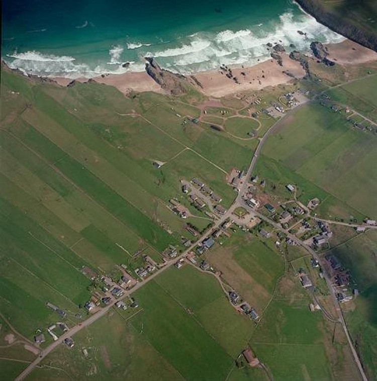
The Ceannabeinne Walk.
From Gaelic "End of the Mountains"
This walk takes around three to four hours, is about nine kilometres yet exhilarating taking the walker three hundred and eighty three metres above sea level to the summit of Beinn Ceannabeinne. The route along the course of ' Allt Smoo.' illustrates directly some of the classic ways rivers help form landscapes.
The Walk.
Starting at the sink hole where the Allt Smoo burn flows into Smoo Cave walk upstream on the left hand side of the river for about two kilometres. Follow the burn to the left to a path. Arriving at a gate continue and make for the saddle between Beinn Ceannabeinne and Meal Meadhonach. Remain on the path for one and three quarter kilometres until it crosses on to the left hand side of the burn again. At this point turn off to towards the left leaving the path and climbing up a small glen starting to ascend Beinn Ceannabeinne. From the glen the summit can be easily reached. For the descent do not walk in a direct direction towards Durness as this leads to a difficult decline encountering cliffs. Walk in a north east direction toward "An Dubh-Sgeir" the island out at sea. This will lead to a glen with a stream. Follow the course of the water through the tract of Ceannabeinne to the A838 road, turn left and walk back to Allt Smoo.
What to look for.
The grey coloured stone, which forms the river bed on the first part of Allt Smoo, is limestone, originating from the hard remains of creatures such as molluscs and corals. Limestone in the Durness confine is about five hundred million years old. In the river bed hollows can be seen on the surface of the limestone ground worn out by the action small stones, driven by the currents, and scraping the surface. Limestone is comparatively soluble especially in acid conditions, as is Allt Smoo that runs off the peat moors. This zone is prone to this kind of erosion. Further upstream where the river bed is not limestone but Lewisian gneiss such hollowing is far less common.
River courses are constantly changing and the larger the river the smaller these changes tend to be. Allt Smoo is a small young river and in some stretches, quite large alterations in course are obvious. In the vicinity of the fence, the U bends have occurred because a course through easily reduced material is available. The U bends being made redundant as localised erosion cuts a more direct path. Along the course of Allt Smoo a few U bends are in use and spotting redundant ones overgrown with heather, and moss can be challenging.
At the upper reaches of Allt Smoo, a small V shaped glen has been created. This has probably occurred because the river has held the same course for many years having a permanent effect in the landscape. Glaciation during the Pleistocene period was responsible for sculpturing the larger landscape with topological features present today. The north west face of Beinn Ceannabeinne has a series of cliffs and craggy slopes produced by the plucking action of a glacier as it passed over the mass of Lewisian gneiss rock heading in a north west direction toward Faraid Head. The south east side is relatively rounded with no cliffs or crags due to it being scraped rather than plucked by glacier movement.
The saddle between Beinn Ceannabeinne and Meal Meadionach is known as Baelach Beag and is part of an old route from Durness to the Port-na-con Ferry. This pass was in use until the late 19th century before the road was built around the coast.
From the summit of Beinn Ceannabeinne, Faraid Head is in the fore ground to the north west. To the east, Whiten Head the cliffs of which are among the highest in the United Kingdom. To the south east the ragged summit of Ben Hope can be seen in the background overlooking Loch Eriboll. Looking south the dominant summit of Beinn Spionnaidh with Foinaven just visible in the background makes clear how Beinn Ceannabeinne was named.
The Cape / Kearvaig Walk.
From the Norse for Galley
This walk is about six kilometres and can comfortably be completed in four hours. This walk should can only be performed between May and September as arrangements must be made with the minibus driver and ferryman. Only attempt this expedition in good weather. The walk covers some quite rough ground heading in a south east direction from Cape Wrath Lighthouse to Kearvaig Bay along a spectacular cliff top route. Care must be taken on the cliffs; fences should never be crossed, as erosion is constantly occurring. Many seabirds can be seen.
The Walk
From the lighthouse, follow the road until a track leads off to the left. Follow this path up to the old signal buildings on the hill. Behind these buildings, a summit with a cairn can be seen. Walk to the cairn with Dunan Mor on the right (Mor means large and Dunan Fort). This area probably was named due to the lay of the land looking as if it covered the remains of a fort. From the cairn walk in a south east direction viewing Geodha Glas (Sea gulley or cleft, Glas means grey) following the sea cliffs. Climb the small wall, make for the left of the small loch, just before reaching the jetty. A detour inland is required here at Clais Charnach (small stony valley) to find a suitable approach to the jetty. On leaving the jetty ascend the slope to the moorland plain and follow the cliff to Geodha na Seamraig (Seamraig means four leafed clover) and the view of Kearvaig Bay. The name is believed to have derived from the Norse boats (Galleys) landing here. Continue to trace the cliff top until a descent to the Kearvaig River, which is easily crossed. After exploring the Kearvaig Bay, walk up the track from behind Kearvaig house to the arranged pick up point for the mini bus.
What to look for.
The old ruins on the hill behind the lighthouse are the remains of Lloyds signal station. The station opened in the 1930s and all passing shipping had to signal to the station information about cargo, port of departure and estimated time of arrival at next port.
The supply jetty was used when the lighthouse was stocked and serviced from the Pole Star supply ship. The seven green tanks at the jetty held thirteen thousand gallons of diesel each. Collectively they were able to supply the energy requirements of the light house for one year.
The Common Seal (Phoca vitulina) can usually be seen at the jetty. In June and July, young often bask on the rocks. These seals mainly eat bottom dwelling fish, do not live in herds and live for between twenty to thirty years.
Stack Clo Kearvaig has in recent years become known as the Cathedral. It has two spires at either end and a window can be seen in the centre just below the base of the two spires.
Durness, Scotland